Map - Ibaraki Prefecture (Ibaraki)

Ibaraki Prefecture (Ibaraki)
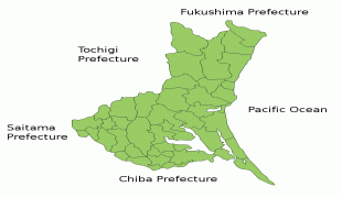
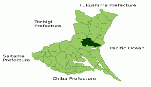
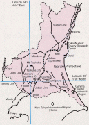
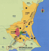
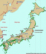
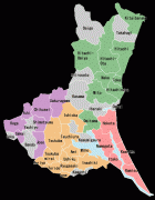
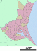
Ibaraki Prefecture (茨城県) is a prefecture of Japan located in the Kantō region of Honshu. Ibaraki Prefecture has a population of 2,871,199 (1 June 2019) and has a geographic area of 6,097.19 km2. Ibaraki Prefecture borders Fukushima Prefecture to the north, Tochigi Prefecture to the northwest, Saitama Prefecture to the southwest, Chiba Prefecture to the south, and the Pacific Ocean to the east.

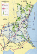
Mito, the capital, is the largest city in Ibaraki Prefecture. Other major cities include Tsukuba, Hitachi, and Hitachinaka. Ibaraki Prefecture is located on Japan's eastern Pacific coast to the northeast of Tokyo, and is part of the Greater Tokyo Area, the most populous metropolitan area in the world. Ibaraki Prefecture features Lake Kasumigaura, the second-largest lake in Japan; the Tone River, Japan's second-longest river and largest drainage basin; and Mount Tsukuba, one of the most famous mountains in Japan. Ibaraki Prefecture is also home to Kairaku-en, one of the Three Great Gardens of Japan, and is an important center for the martial art of Aikido.

Ibaraki Prefecture was previously known as Hitachi Province. In 1871, the name of the province became Ibaraki, and in 1875 it became its current size, by annexing some districts belonging to the extinct Shimōsa Province.

 
Map - Ibaraki Prefecture (Ibaraki)
Map
ibaraki3.jpg
800x1154
www.alientimes.org
article-1365414-0D92...
940x964
i.dailymail.co.uk
IbarakiMapCurrent.pn...
1001x901
upload.wikimedia.org
Mito_in_Ibaraki_Pref...
1001x901
upload.wikimedia.org
ibaraki4.jpg
800x1116
www.alientimes.org
ibaraki5.jpg
800x1108
www.alientimes.org
ibaraki1.jpg
800x1082
www.alientimes.org
ibaraki2.jpg
800x1064
www.alientimes.org
ibaraki6.jpg
800x831
www.alientimes.org
map_ibaraki.jpg
960x669
e-heya.kentaku.net
map_ibaraki.jpg
950x669
www.eheya.net
Map.jpg
677x800
www.japanfocus.org
800px-JP_Ibaraki_Pre...
800x516
wikitravel.org
map01.gif
501x706
www.dc-ibaraki.or.jp
507px-Japan_Tohoku_M...
507x599
4.bp.blogspot.com
map_pal_tohokueq_110...
480x601
www.eorc.jaxa.jp
map.gif
465x597
www.ia-ibaraki.or.jp
Ibaraki_Prefecture.p...
435x600
japan.resiliencesyst...
Ibaraki%252BEarthqua...
366x621
2.bp.blogspot.com
japan_map_2.gif
434x505
sprintdiaries.files....
Country - Japan
Flag of Japan
Japan (日本, or, and formally 日本国, Nihonkoku) is an island country in East Asia. It is situated in the northwest Pacific Ocean and is bordered on the west by the Sea of Japan, extending from the Sea of Okhotsk in the north toward the East China Sea, Philippine Sea, and Taiwan in the south. Japan is a part of the Ring of Fire, and spans an archipelago of 6852 islands covering 377,975 km2; the five main islands are Hokkaido, Honshu (the "mainland"), Shikoku, Kyushu, and Okinawa. Tokyo is the nation's capital and largest city, followed by Yokohama, Osaka, Nagoya, Sapporo, Fukuoka, Kobe, and Kyoto.

Japan is the eleventh most populous country in the world, as well as one of the most densely populated and urbanized. About three-fourths of the country's terrain is mountainous, concentrating its population of 124.8 million on narrow coastal plains. Japan is divided into 47 administrative prefectures and eight traditional regions. The Greater Tokyo Area is the most populous metropolitan area in the world, with more than 37.2 million residents.
Currency / Language  
ISO Currency Symbol Significant figures
JPY Japanese yen ¥ 0
ISO Language
JA Japanese language
Neighbourhood - Country